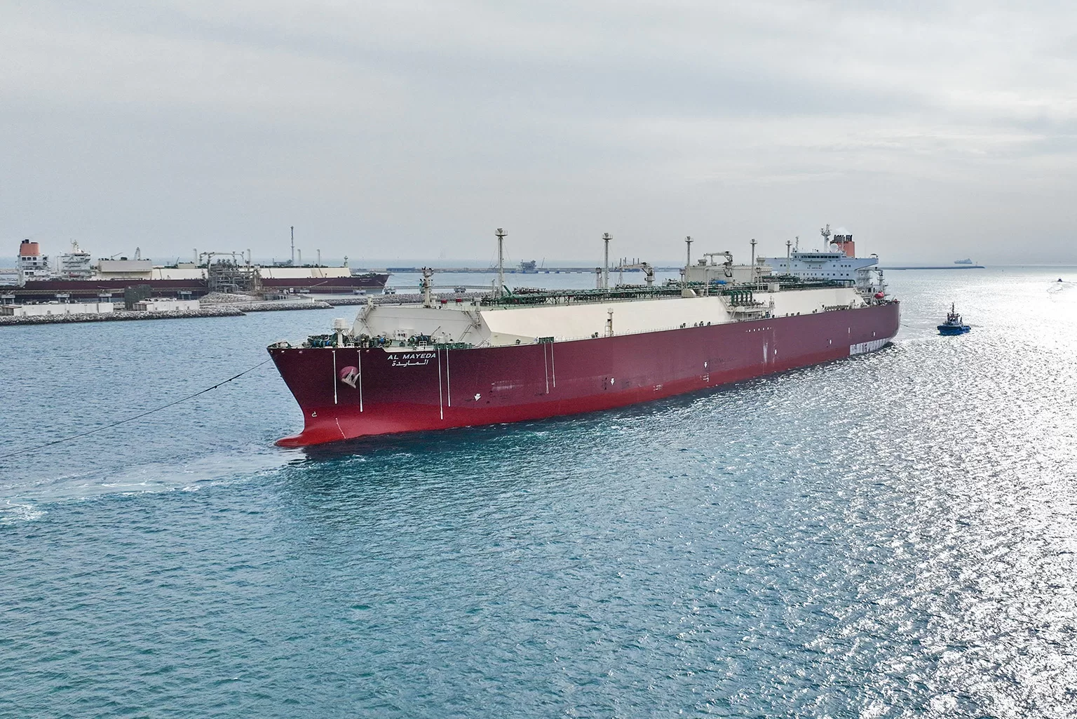
We extend our services at all Qatari Ports and Terminals
Al Shaheen Terminal
Al Rayyan Terminal
Halul Usland Terminal
Mesaieed SPM
Ras Laffan SPM
And all other offshore locations in Qatar
Al Rayyan Terminal
Port Guideline
Overview
Al Rayyan Marine Terminal is situated in the Southern part of the Arabian Gulf approximately 35 nautical miles off the Northern coast of Qatar. The approximate geographical location of the Terminal is latitude 26˚ 41’ North and longitude 51˚ 35’ East. The approximate water depth at the Terminal is 29 meters at British Admiralty chart datum (Lowest Astronomical Tide).
Channel Approach/Departure
Safe approach to the Terminal is from the North, then proceeding to the pilot boarding position 3 nautical miles to East of the Terminal.The Terminal is situated near busy shipping lanes and Masters of visiting vessels are cautioned accordingly.
The appropriate British Admiralty chart for the area shall be consulted. The old SBM in position latitude 26° 39’ North and longitude 51° 34’ East, has been removed. The old SBM pipeline and PLEM have been left in position and the area is to be avoided at all times. There is a back down buoy for the Tug to tie up to in position, latitude 26° 39.7’ North and Longitude 51° 33.8’ East. There is a STP ( Sensor Tower Platform) jacket located to the east of Platform in position Latitude 26° 39’04.28 North and Longitude 51° 34’ 55.07East. This has a light and radar. The area 500 meters around this jacket is to be avoided.
Draught and Trim
Maximum vessel draft at the Terminal is restricted to 21 meters. Arriving Vessels shall have their propeller(s) fully submerged and have a reasonable stern trim not exceeding 3 meters. A vessel with an insufficient draft or excessive trim will not be berthed until the draft condition has been corrected to the satisfaction of the Pilot.
It should be noted that the distances and coordinates given are approximate and should not be used for navigational purposes. Reference should therefore be made to the appropriate Hydrographic Office publications, Admiralty publications and official charts for the purposes of obtaining navigational information.
Al Shaheen Terminal
Port Guideline
Overview
The Al Shaheen terminal is operated by North Oil Company (NOC) in the State of Qatar. TheTerminal is located approximately 80 NM NNE of the capital city of Doha; the centre is in position 26° 35’N 52° 00’E. The depth of water is approximately 62 meters. The terminal consists of Floating Storage and Offloading units (FSOs) each moored to an SPM.Note: Anchoring under any circumstances is prohibited within NOC operating area including the Al Shaheen Field and Terminal, apart from the designated anchorage area. The main pilot station / arrival point where the mooring master should join the export vessel is designated as: Lat: 26° 33’ N Lon: 052° 04’ E
Location of SPM
SPM2 : 26° 35.496′ N 52° 01.987′ E
SPM3 : 26° 38.802′ N 51° 53.470′ E
SPM4 : 26° 40.379′ N 51° 53.869’ E
It should be noted that the distances and coordinates given are approximate and should not be used for navigational purposes. Reference should therefore be made to the appropriate Hydrographic Office publications, Admiralty publications and official charts for the purposes of obtaining navigational information.
Ras Laffan SPM
Port Guideline
SPM Facility
The Port Limits of Ras Laffan are bound by the following geographical coordinates:
There are two SPMs of the CALM design, positioned as follows:
CALM 1 26° 00’ 33.64’’N 052° 03’ 39.48’’E
CALM 2 26° 00’ 40.59’’N 052° 04’ 51.01’’E
SPM Anchorage is within the following coordinates:
26° 02.4’N 052° 11.4’E
26° 02.4’N 052° 13.2’E
26° 00.8’N 052° 11.4’E
26° 00.8’N 052° 13.2’E
Al Ruwais Port
Port Guideline
Overview
Al Ruwais Port is located on the northern tip of Qatar, approximately 127 km north of the capital Doha
Port Coordinates

Channel Details
Length: 2 Nm
Depth: 5.0m
Width: 100m
Max draft: 4.8m
Ras Laffan Port
Port Guideline
Overview
Situated on the North East coast of Qatar, in Latitude 25 55.5’N Longitude 5136.5’E, the purpose built Port of Ras Laffan (RLC) has been designed as the export facility for Liquefied Natural Gas (LNG), Liquid Petroleum Gas (LPG), Condensates, Petroleum Products and Sulphur which are all derived from the processing of gas extracted from the North Field Gas Reservoir situated 67 km NNE of the Port.
Port Limits
The Port of Ras Laffan consists of the Port and the SPM facility.
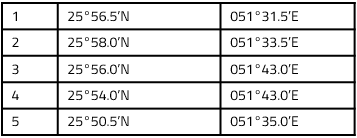
Port Coordinates
The Port Limits of Ras Laffan are bound by the following geographical coordinates:
Halul Terminal
Port Guideline
Overview
Halul Island (position 25 40.3’N 052 24.6’E) is 52 miles Northeast of Doha. The Terminal serves as the Export Terminal for Qatar Marine Crude oil, which is produced from the offshore oilfields area. There is a harbour on the southern side of the island, which is only for the use of small craft and offshore support vessels. Halul is part of the State of Qatar and is managed and operated by Qatar Petroleum. (Ref: Emiri Decree No.35 of 1994)
Channel Approach/Departure
To the East of Halul there are two buoys marking a deep-water channel, which is the recommended channel for all tankers approaching or departing from the SBMs.
H-1 – Green conical – Quick flash green
H-2 – Red can – Quick flash red
The offshore oilfields are prohibited for routine navigation because of the numerous production stations, drilling rigs, wellhead jackets and oil/gas pipelines. A 500 meter restricted access zone around the oil/gas platforms, installations, SBM’s is enforced.
Hamad Port
Port Guideline
Overview
Hamad Port is Qatar’s main seaport, located south of Doha in the Umm Al-Houl area. The terminal (CT3) is operated by Mwani Qatar.
Port Coordinates
Anchorage Details
Depth : minimum 12m – maximum 20m
Area size : B 3 x 2 Miles and A 3.65 x 3.2 Miles
Channel Details
Length/width : West channel 6.5 miles / 500 m , Hamad Port channel 5.5 miles / 300m
Depth (Lowest Astronomical Tide or Chart Datum Level : C.D.L.) : 15 (CD)
U K C (Under Keel Clearance) : 1m
Max. draft : 14m
Mesaieed Port
Port Guideline
Mesaieed Port
Overview
Mesaieed Port is located in a natural bay about half way south on the east coast of the State of Qatar, approximately 45 km. south of Doha. The port limits lie between Latitudes 24 53’ N and 24 58’ N. and Longitudes 51 33’ E. and 51 37’ E. Mesaieed Port lies in the industrial heartland of the country and is the premier Port in Qatar providing services to Petrochemical, metallurgical plants and construction related industries through 29 active berths.
Port Limits
Mesaieed Port limits are between Lat. 24 50’ N and Lat. 025 14’ N; and from 5.5 km from the eastern coastline to Long. 051 48.50’ E. The port is located in a natural bay on the East coast of Qatar, approximately 45 km south of Doha. Mesaieed Port limits include the Inner Harbour and the Outer Channels to the Mesaieed Approach Buoy.
Channel Transit
Maximum Beam of vessels calling at Mesaieed Port is 60 meters.
Maximum Draft for VLCC is 12.5 meters and 13.0 meter for all other vessels.
Maximum trim for all vessels is 3.0 meters.
Navigational Information
NaN
BA Chart No. : 3787 & 3783
ENC CELL: GB55062C, GB45062A and GB303950
Admiralty Pilot: No.63
Tide table ATT 3
Admiralty List of Lights and Fog Signals D (NP77)
Port working hours: 24 / 7
The Port Control is available 24 hours/day for communications on VHF Ch-11/16 and on following numbers +974 4013 8502/03.
